Tuesday, 29 September 2020

Hungary flag

 The flag of Hungary (Hungarian: Magyarország zászlaja) is a horizontal tricolour of red, white and green. In this exact form, it has been the official flag of Hungary since 23 May 1957. The flag's form originates from national republican movements of the 18th and 19th centuries, while its colours are from the Middle Ages. The current Hungarian tricolour flag is the same as the republican movement flag of the United Kingdom (used since 1816) and the colours in that form were already used at least since the coronation of Leopold II in 1790, predating the first use of the Italian Tricolour in 1797.

 Courtesy of Dédé11 from postcrossing forum


Tuesday, 7 August 2018

Fiji Map

Fiji (Fijian: Viti [ˈβitʃi]; Fiji Hindi: फ़िजी), officially the Republic of Fiji (Fijian: Matanitu Tugalala o Viti; Fiji Hindi: फ़िजी गणराज्य), is an island country in Oceania in the South Pacific Ocean about 1,100 nautical miles (2,000 km; 1,300 mi) northeast of New Zealand's North Island. Its closest neighbours are Vanuatu to the west, New Caledonia to the southwest, New Zealand's Kermadec Islands to the southeast, Tonga to the east, the Samoas and France's Wallis and Futuna to the northeast, and Tuvalu to the north.
Fiji is an archipelago of more than 330 islands—of which 110 are permanently inhabited—and more than 500 islets, amounting to a total land area of about 18,300 square kilometres (7,100 sq mi). The farthest island is Ono-i-Lau. The two major islands, Viti Levu and Vanua Levu, account for 87% of the total population of 898,760. The capital, Suva on Viti Levu, serves as Fiji's principal cruise port. About three-quarters of Fijians live on Viti Levu's coasts, either in Suva or in smaller urban centres like Nadi (with tourism being the major industry) or Lautoka (sugar cane industry). Viti Levu's interior is sparsely inhabited due to its terrain.

Mauritius Map

Mauritius (French: Maurice), officially the Republic of Mauritius (French: République de Maurice), is an island nation in the Indian Ocean about 2,000 kilometres (1,200 mi) off the southeast coast of the African continent. The country includes the islands of Mauritius and Rodrigues, 560 kilometres (350 mi) east of Mauritius, and the outer islands (Agaléga, St. Brandon and two disputed territories). The islands of Mauritius and Rodrigues form part of the Mascarene Islands, along with nearby Réunion, a French overseas department. The area of the country is 2,040 km2 (790 sq mi). The capital and largest city is Port Louis. It is a member of the Commonwealth, La Francophonie and the African Union.


Sunday, 29 July 2012

India flag


The National flag of India is a horizontal rectangular tricolour of deep saffron, white and dark green; with the Ashok Chakra, a 24-spoke wheel, in navy blue at its centre.[1] It was adopted in its present form during a meeting of the Constituent Assembly held on 22 July 1947, when it became the official flag of the Dominion of India. The flag was subsequently retained as that of the Republic of India. In India, the term "tricolour" (Hindi: तिरंगा, Tirangā) almost always refers to the Indian national flag. The flag is based on the Swaraj flag, a flag of the Indian National Congress designed by Pingali Venkayya.

The saffron color represents courage and sacrifice; white – truth and purity; green – peace and prosperity; and the Ashok Chakra represents the Laws of Dharma (righteousness).

French Polynesia - Society Islands map

French Polynesia (French: Polynésie française) is an overseas country (pays d'outre-mer) of the French Republic. It is made up of several groups of Polynesian islands, the most famous island being Tahiti in the Society Islands group, which is also the most populous island and the seat of the capital of the territory (Papeetē).

The Society Islands (French: Îles de la Société or officially Archipel de la Société) are a group of islands in the South Pacific Ocean. They are politically part of French Polynesia. The archipelago is suspected to have been named by Captain James Cook supposedly in honour of the Royal Society, the sponsor of the first British scientific survey of the islands; however, Cook himself stated in his journal that he called the islands Society "as they lay contiguous to one another".

French Guiana map


French Guiana (French: Guyane française; officially just Guyane) is an overseas region of France on the North Atlantic coast of South America. It has borders with two nations: Brazil to the east and south, and Suriname to the west. Its 83,534 km2 (32,253 sq mi) have a very low population density of less than 3 /km2 (7.8 /sq mi), with half of its 236,250 people in 2011 living in the metropolitan area of Cayenne, its capital.

Costa Rica map

Costa Rica is a country in Central America, bordered by Nicaragua to the north, Panama to the southeast, the Pacific Ocean to the west, and the Caribbean Sea to the east.

India map

Courtesy of nagi from India

India, officially the Republic of India, is a country in South Asia. It is the seventh-largest country by area, the second-most populous country with over 1.2 billion people, and the most populous democracy in the world. Bound by the Indian Ocean on the south, the Arabian Sea on the south-west, and the Bay of Bengal on the south-east, it shares land borders with Pakistan to the west; China, Nepal, and Bhutan to the north-east; and Burma and Bangladesh to the east. In the Indian Ocean, India is in the vicinity of Sri Lanka and the Maldives; in addition, India's Andaman and Nicobar Islands share a maritime border with Thailand and Indonesia.

Tuesday, 10 April 2012

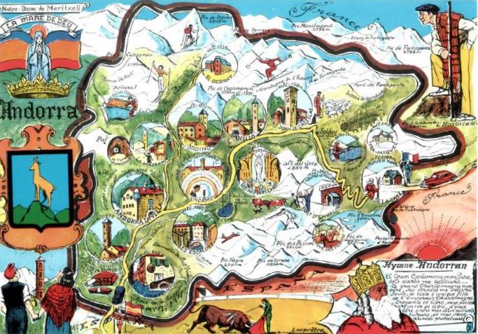
Andorra map

Courtesy of Svea from Germany

Andorra, officially the Principality of Andorra, also called the Principality of the Valleys of Andorra, is a small landlocked country in southwestern Europe, located in the eastern Pyrenees mountains and bordered by Spain and France. It is the sixth smallest nation in Europe having an area of 468 km2 (181 sq mi) and an estimated population of 84,082 in 2009. Its capital, Andorra la Vella, is the highest capital city in Europe, at an elevation of 1,023 metres (3,356 ft) above sea level. The official language is Catalan, although Spanish, Portuguese, and French are also commonly spoken.

Monday, 27 February 2012

Portugal flag

Courtesy of C4ss from postcrossing forum

The Flag of Portugal is the national flag of the Portuguese Republic. It is a rectangular bicolour with a field unevenly divided into green on the hoist, and red on the fly. The lesser version of the national coat of arms is centred over the colour boundary at equal distance from the upper and lower edges.

The conjugation of the new field colours, especially the use of green, was not traditional in the Portuguese national flag's composition and represented a radical republican-inspired change that broke the bond with the former religious monarchical flag. These colours were popularly propagandized as representing the hope of the nation (green) and the blood (red) of those who died defending it, as a means to endow them with a more patriotic and dignified, therefore less political, sentiment.

Poland flag

Courtesy of Lidia from g+

The flag of Poland consists of two horizontal stripes of equal width, the upper one white and the lower one red. The two colors are defined in the Polish constitution as the national colors. The national flag was officially adopted in 1919. Since 2004, Polish Flag Day is celebrated on May 2.

Cuba flag

Courtesy of Lidia from g+
The Cuban flag was created by Narciso López in June 25, 1849, and put together by Emilia Teurbe Tolón. The Cuban flag's origins date from 1849, when various movements to liberate Cuba from Spanish rule emerged, mainly among Cuban exiles in the United States. Anti-Spanish Cuban exiles under the leadership of Narciso López adopted a flag suggested by the poet Miguel Teurbe Tolón. His design incorporates three blue stripes, representing the three parts that the country was divided during the independence wars, central, occidental, and oriental areas of the country, and two white stripes symbolizing the purity of the patriotic cause. The red triangle (triangle of Masonic significance) stands for the blood shed to free the nation, which is placed where the star is, symbolizing the sky turned red from the blood shed in battle. The white star in the triangle stands for independence.

Thursday, 17 November 2011

Ukraine map

Courtesy of CatHouse from postcrossing forum


Ukraine (Ukrainian: Україна) is a country in Eastern Europe. It has an area of 603,628 km², making it the second largest contiguous country on the European continent, after Russia. Ukraine borders the Russian Federation to the east and northeast, Belarus to the northwest, Poland, Slovakia and Hungary to the west, Romania and Moldova to the southwest, and the Black Sea and Sea of Azov to the south and southeast, respectively.

Sunday, 18 September 2011

USA map


The United States of America (also called the United States, the States, the U.S., the USA, and America) is a federal constitutional republic comprising fifty states and a federal district. The country is situated mostly in central North America, where its forty-eight contiguous states and Washington, D.C., the capital district, lie between the Pacific and Atlantic Oceans, bordered by Canada to the north and Mexico to the south. The state of Alaska is in the northwest of the continent, with Canada to the east and Russia to the west across the Bering Strait. The state of Hawaii is an archipelago in the mid-Pacific. The country also possesses several territories in the Pacific and Caribbean.

Belarus map

Courtesy of Lummy from postcrossing

Belarus (Belarusian: Беларусь), officially the Republic of Belarus, is a landlocked country in Eastern Europe, bordered clockwise by Russia to the northeast, Ukraine to the south, Poland to the west, and Lithuania and Latvia to the northwest. Its capital is Minsk; other major cities include Brest, Grodno (Hrodna), Gomel (Homiel), Mogilev (Mahilyow) and Vitebsk (Vitsebsk). Over forty percent of its 207,600 square kilometres (80,200 sq mi) is forested, and its strongest economic sectors are agriculture and manufacturing.

Greece flag

Courtesy of lindseylee from go2eu

The flag of Greece (popularly referred to as the galanolefki or the kianolefki, the "blue-white"), officially recognized by Greece as one of its national symbols, is based on nine equal horizontal stripes of blue alternating with white. There is a blue canton in the upper hoist-side corner bearing a white cross; the cross symbolizes eastern orthodox christianity, the established religion of the Greek people of Greece and Cyprus. According to popular tradition, the nine stripes represent the nine syllables of the phrase "Ελευθερία ή Θάνατος" ("Freedom or Death", " E-lef-the-ri-a i Tha-na-tos"), the five blue stripes for the syllables "Έλευθερία" and the four white stripes "ή Θάνατος". The nine stripes are also said to represent the letters of the word "freedom" (Greek: Ελευθερία). There is also a different theory, that the nine stripes symbolize the nine Muses, the goddesses of art and civilization (nine has traditionally been one of the numbers of reference for the Greeks). The official flag ratio is 2:3.

The above patterns were officially adopted by the First National Assembly at Epidaurus on 13 January 1822. Blue and white have many interpretations, symbolizing the colours of the famed Greek sky and sea (combined with the white clouds and waves), traditional colours of Greek clothes in the islands and the mainland, etc.

Friday, 16 September 2011

Philippines flag


The national flag of the Philippines (Tagalog: Pambansang Watawat ng Pilipinas) is a horizontal flag bicolor with equal bands of royal blue and scarlet red, and with a white equilateral triangle at the hoist; in the center of the triangle is a golden yellow sun with eight primary rays, each containing three individual rays, which represent the country's provinces; and at each vertex of the triangle is a five-pointed golden yellow star, each of which, represent the country's 3 main islands, Luzon, Visayas and Mindanao. This flag can indicate a state of war if it is displayed with the red side on top.

Saturday, 30 July 2011

China Map

China ethnic groups map

The People's Republic of China (PRC), commonly known as China, is the most populous state in the world, with over 1.3 billion citizens. Located in East Asia, it is a single-party state governed by the Communist Party of China (CPC). The PRC exercises jurisdiction over 22 provinces, five autonomous regions, four directly administered municipalities (Beijing, Tianjin, Shanghai, and Chongqing), and two highly autonomous special administrative regions (SARs) – Hong Kong and Macau. Its capital city is Beijing.

At about 9.6 million square kilometres (3.7 million square miles), the PRC is the world's third- or fourth-largest country by total area, depending on the definition of what is included in that total,[16] and the second largest by land area.[17] Its landscape is diverse, with forest steppes and deserts (the Gobi and Taklamakan) in the dry north near Mongolia and Russia's Siberia, and subtropical forests in the wet south close to Vietnam, Laos, and Burma. The terrain in the west is rugged and elevated, with the Himalayas and the Tian Shan mountain ranges forming China's natural borders with India, Nepal and Central Asia. In contrast, mainland China's eastern seaboard is low-lying and has a 14,500-kilometre (9,000 mi) long coastline (the 11th longest in the world), bounded on the southeast by the South China Sea and on the east by the East China Sea, beyond which lie Taiwan, Korea, and Japan.

Tuesday, 19 July 2011

Cape Verde map

Courtesy of Gilles from postcrossing forum
The Republic of Cape Verde (Portuguese: Cabo Verde) is an island country, spanning an archipelago of 10 islands located in the central Atlantic Ocean, 570 kilometres off the coast of Western Africa. The islands, covering a combined area of slightly over 4,000 square kilometres (1,500 sq mi), are of volcanic origin and while three of them (Sal, Boa Vista and Maio) are fairly flat, sandy and dry, the remaining ones are generally rockier and have more vegetation. Because of the infrequent occurrence of rainfall the overall landscape is not particularly green, despite what the country's name suggests (verde is Portuguese for "green"). The name of the country stems instead from the nearby Cap Vert, on the Senegalese coast.

Saturday, 25 June 2011

Morocco map

Courtesy of Tine from picasa
Morocco, officially the Kingdom of Morocco, is a country located in North Africa. It has a population of nearly 34 million and an area of 710,850 km², and also primarily administers the disputed region of the Western Sahara.